Browse Resources
Resources |
|---|
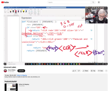 This video lesson, provided by the GeoTech Center, is from the fifth module of the Python and Geospatial Mapping course, titled Python with Labeling and Calculate Field. The course is designed for experienced users of Global Information Systems (GIS) platforms who are new to programming, with the...
 This video assignment, provided by the GeoTech Center, is the first assignment from module five of the Python and Geospatial Mapping course, titled Python with Labeling and Calculate Field. The course is designed for experienced users of Global Information Systems (GIS) platforms who are new to...
 This video assignment, provided by the GeoTech Center, is the second assignment from module five of the Python and Geospatial Mapping course, titled Python with Labeling and Calculate Field. The course is designed for experienced users of Global Information Systems (GIS) platforms who are new to...
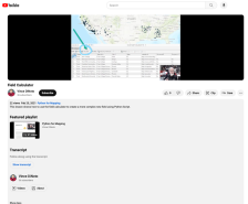 This video lesson, provided by the GeoTech Center, is from the fifth module of the Python and Geospatial Mapping course, titled Python with Labeling and Calculate Field. The course is designed for experienced users of Global Information Systems (GIS) platforms who are new to programming, with the...
 This video lesson, provided by the GeoTech Center, is from the fifth module of the Python and Geospatial Mapping course, titled Python with Labeling and Calculating Field. The course is designed for experienced users of Global Information Systems (GIS) platforms who are new to programming, with the...
 Learning Unit Description:
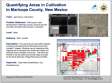
The Integrated Geospatial Education and Technology Training Project (iGETT) presents a series of Learning Units (LU) designed to incorporate federal land remote sensing data into Geographic Information System (GIS) instruction. The Quantifying Areas in Cultivation in...
 Learning Unit Description:
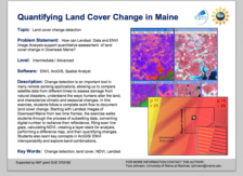
The Integrated Geospatial Education and Technology Training Project (iGETT) presents a series of Learning Units (LU) designed to incorporate federal land remote sensing data into Geographic Information System (GIS) instruction. The Quantifying Land Cover Change in Maine...
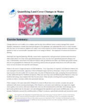 This exercise, created by the Integrated Geospatial Education and Technology Training Project (iGETT), uses real-world Landsat data on vegetation from northeastern Maine to assess changes in ground cover over four years as it relates to blueberry cultivation and its impact on the local environment....
 This video, provided by Virginia Geospatial Extension, is part of a series of 28 tutorial videos on remote sensing with ArcGIS Pro. This tutorial "uses ArcGIS Pro version 2.3 to illustrate radiometric enhancement of Landsat 8 imagery to include brightness, contrast, gamma, dynamic range adjustment...
 This tutorial, provided by Virginia Geospatial Extension, is part of a series of 30 videos that cover remotely sensed data in ArcMap 10.x versions. This tutorial is broken into two videos (14A and 14B) and covers "radiometric enhancement of Landsat Imagery." This video runs 02:26 minutes in length....
|
| ← PreviousNext → |