Browse Resources
Information and Security Technologies -- Geospatial technologies
Resources |
|---|
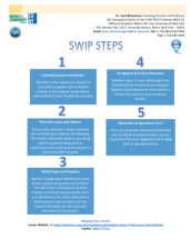 This 22-page document provides information about the application process for the Summer Workforce Internship Program (SWIP) held by the BCC Geospatial Center of the CUNY CREST Institute. The goal of the SWIP "is to train participants in industry relevant geospatial and STEM research projects."...
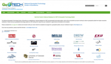 This website, from the National Geospatial Technology Center of Excellence, is a national database for GIST and geospatial technology syllabi. The syllabi are accessible to any users who want to observe geospatial syllabi from higher education institutions. Syllabi are provided free for download...
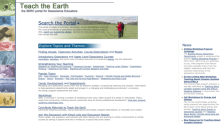 Teach the Earth is a portal into the rich geoscience education content available through dozens of independent project websites. The Teach the Earth portal is a handful of web pages which can help guide you through this diverse array of sites. It includes a search interface spanning all the...
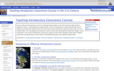 This web module, part of the professional development resources from On the Cutting Edge - Strong Undergraduate Geoscience Teaching, is for those who teach introductory earth science courses. Here you will find ideas for designing a new course, spicing up an existing course design, or adding...
 This video, from the 2021 Esri Education Summit, discusses teaching modern remote sensing. Viewers will "learn about new teaching materials to aid the development of university-level curricula for imagery and remote sensing." The video also covers "... imagery workflows and ready-to-use data apps,...
 This video, from the 2021 Esri Education Summit, provides three presentations about the suite of web-based tools in the ArcGIS School Bundle. In the first presentation, Judith Bock explores the integration of geospatial technologies into AP Human Geography courses. Bock highlights a curriculum...
 This 2-page document explores the growing and changing field of surveying due to the incorporation of new technologies such as GPS, GIS, and remote sensing. Here, the Geospatial Technology Competency Model (GTCM) is addressed and contextualized for instructors. The GTCM formally outlined some of the...
 This resource, created by The GIS 2 GPS Portal Resources For Educators & Students, "want[s] to make educators and students aware of these two new emerging technologies, Geographical Information System (GIS), Global Positioning System (GPS), and Remote Sensing (RS)." The resource contains links to...
 This video, from the 2021 Esri Education Summit, highlights three presentations about GIS projects in education. In the first presentation, Curby Alexander describes the use of ArcGIS for a longitudinal study of urban turtles. Curby explores the project, converting data into ArcGIS, visualization,...
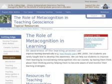 This website, from the program On the Cutting Edge - Strong Undergraduate Geoscience Teaching, focuses on metacognition and its role in geoscience education. Metacognition, broadly, is defined as "thinking about thinking," and can help students monitor and adjust their own learning strategies to...
|
| ← PreviousNext → |