Browse Resources
Resources |
|---|
 This module is provided by GeoTech Center, and introduces the horizontal and vertical datums. This learning module stresses the importance of datums in geographic information systems. Module contents include a video recording, a PowerPoint file of the slides from the presentation, a folder of past...
 Course Description:
This eSyst DC/AC Circuits course is provided Maricopa Advanced Technology Education Center (MATEC). This course has 16 student learning outcomes, including: Define systems as it applies to electronics, list and explain the operation of the main building blocks and circuits of...
 Module Description:
This module, from Support Center for Microsystems Education (SCME), introduces "students to the common processes used to deposit thin films in the fabrication of micro-size devices." This module is divided into the following six units: Knowledge Probe (Pre-test), Primary...
 Curriculum Description:
This collection includes all components of the Spring 2021 Integrated Design Thinking curriculum developed by NorthWest Arkansas Community College (NWACC). Design Thinking begins as a framework for discovering and developing solutions that can be applied to a variety of...
 Course Description:
This course was developed by Kettering University and the Center for Advanced Automotive Technology (CAAT). Design with Aluminum is an introductory course focusing on the basics of engineering design, properties, manufacturing processes, design aspects, and design guidelines...
 Course Description:
Design with Composite Materials is provided by Kettering University and the Center for Advanced Automotive Technology (CAAT) and is an introductory course focusing on students learning properties, manufacturing processes, and design guidelines of fiber-reinforced composite...
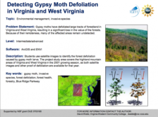 Learning Unit Description:
The Integrated Geospatial Education and Technology Training Project (iGETT) presents a series of Learning Units (LU) designed to incorporate federal land remote sensing data into Geographic Information Systems (GIS) instruction. The Detecting Gypsy Moth Defoliation in...
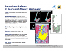 Learning Unit Description:
The Integrated Geospatial Education and Technology Training Project (iGETT) presents a series of Learning Units (LU) designed to incorporate federal land remote sensing data into Geographic Information System (GIS) instruction. The Determining Ecoroof Locations to Improve...
 Learning Unit Description:
The Integrated Geospatial Education and Technology Training Project (iGETT) presents a series of Learning Units (LU) designed to incorporate federal land remote sensing data into Geographic Information System (GIS) instruction. The Determining Greenway Potential in...
 This learning module, provided by Support Center for Microsystems Education, introduces participants to diagnostic BioMEMS, or biological microelectromechanical systems. The module presents information about the areas in diagnostic medicine that are impacted by the introduction of BioMEMS. The...
|
| ← PreviousNext → |